Measured Building Surveys · Glasgow · Edinburgh · Scotland · UK
Measured building surveys,
drawn from the scan.
Accurate 2D CAD drawings of existing buildings — floor plans, elevations and sections — drawn from a LiDAR scan, to your standards, in DWG and PDF. The reliable base drawing your design starts from. Glasgow-based, working UK-wide.
At a Glance
- Capture
- Leica RTC360 laser scanner
- 3D point accuracy 1.9 mm at 10 m (manufacturer spec), plus Matterport Pro3 and drone
- Drawings
- 1:50 or 1:100
- Plans, elevations, sections, roof and site plans, GIA/NIA areas
- Formats
- DWG + PDF
- To your layer standard and title block; point cloud as E57 / RCP
- Site visit
- Usually within the week
- Most flats and houses captured in half a day
- Delivery
- 1–2 weeks
- From the site visit, depending on building size and drawing set
- Quote
- Fixed price, same day
- Agreed before we attend site — no day-rate surprises
- Drawn by
- Chartered Architectural Technologist
- MCIAT — someone who prepares planning and warrant drawings
- Cover
- Fully insured
- Cover details available on request
What You Get
A complete drawing set.
The drawings architects actually need to design — accurate, scaled, and drawn to your CAD standards.
Floor Plans
Scaled, dimensioned plans of every level — walls, openings, fixtures, levels and features — drawn to your layering standard and ready to design over.
Elevations
Accurate external (and internal where needed) elevations showing every opening, string course, and feature in true position — essential for planning and façade work.
Sections
Cut-through sections showing floor-to-floor heights, structure, roof form and level relationships — taken straight from the point cloud, so they reflect the building as built.
Reflected Ceiling & Site Plans
Reflected ceiling plans, roof plans and site/location plans to complete the drawing set — whatever your design stage or planning submission needs.
How It Works
Scan. Draw. Deliver.
Scan
We capture the building with terrestrial and mobile LiDAR — a dense, accurate point cloud of the existing conditions, recorded in a single visit.
Draw
We draw the building up in CAD from the point cloud — floor plans, elevations and sections to your scale, layering and template, not a generic export.
Deliver
You receive a coordinated 2D CAD drawing set in DWG and PDF, ready to design over. Point cloud supplied alongside on request.
Use Cases
What the drawings are for.
Refurbishment & extensions
Accurate existing-condition drawings before design starts — the single best defence against on-site surprises and redesign fees.
Planning applications
Existing floor plans, elevations and sections drawn to the standard planning departments expect for householder and full applications.
Lease & area plans
Measured floor plans with GIA / NIA areas for lease agreements, marketing particulars and space planning.
Heritage & listed buildings
Detailed measured drawings of historic fabric for conservation, listed building consent, and record purposes — captured non-invasively.
Feasibility & design
A reliable base drawing for option studies and design development, so the whole team works from the same accurate set.
As-built records
A drawn record of a building as it actually stands — invaluable for asset management, alterations and future projects.
Where It Fits
One scan, three ways to use it.
We capture your building once. What you take away depends on what you're designing.
The Point Cloud
The raw capture — a dense, measurable 3D record of the building, in your format and coordinate system.
LiDAR Scanning →2D CAD Drawings
Floor plans, elevations and sections drawn from the scan — the base drawing you design over. You're here.
Measured Building SurveyA 3D Revit Model
An intelligent BIM model built from the scan, when you need to design and coordinate in 3D.
Scan-to-BIM →Why Kanna
Drawn by people who design buildings.
Kanna is led by a Chartered Architectural Technologist (MCIAT). We know what a usable base drawing looks like, because we've designed from them — clean layers, the right detail in the right place, and the levels and quirks the design actually has to deal with.
The drawings come from a real LiDAR scan of the building, not a tape and a sketch — so what you design over is what's actually there.
Drawn to your standards
Your CAD layering, title block and template — the set drops straight into your workflow.
Scan-derived accuracy
Plans, elevations and sections taken from a dense point cloud of the real building.
A designer’s eye
MCIAT-led, so the drawings carry the detail design teams need — not a generic export.
Fast fixed quote
Tell us the building and what you need; we confirm a fixed price and scope, usually same day.
Sample Drawings
What you actually receive.
Issued sheets from a recent survey of a four-storey Victorian townhouse in Glasgow's West End — drawn at 1:50 from a Leica RTC360 laser scan, Matterport interior capture and a drone roof survey, and delivered in DWG and PDF. Title blocks removed; click any sheet to open it full size.
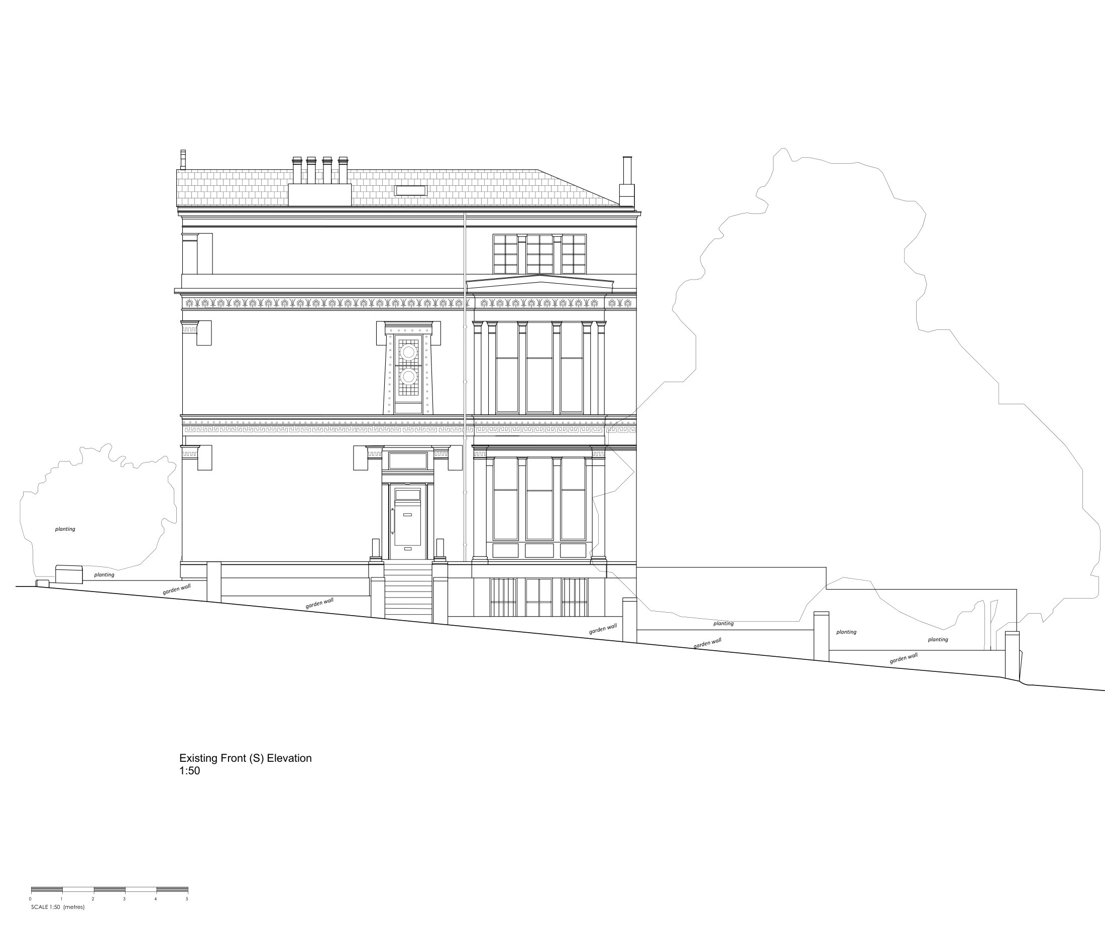
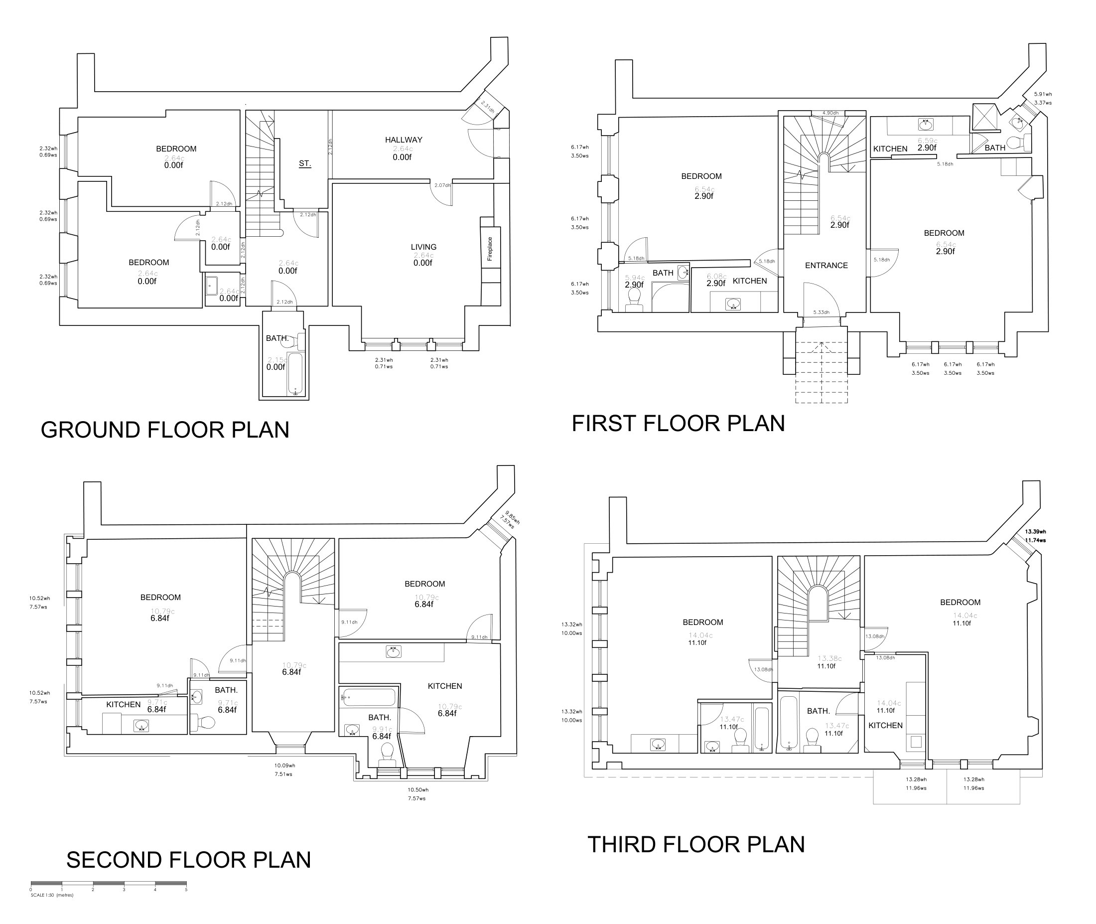
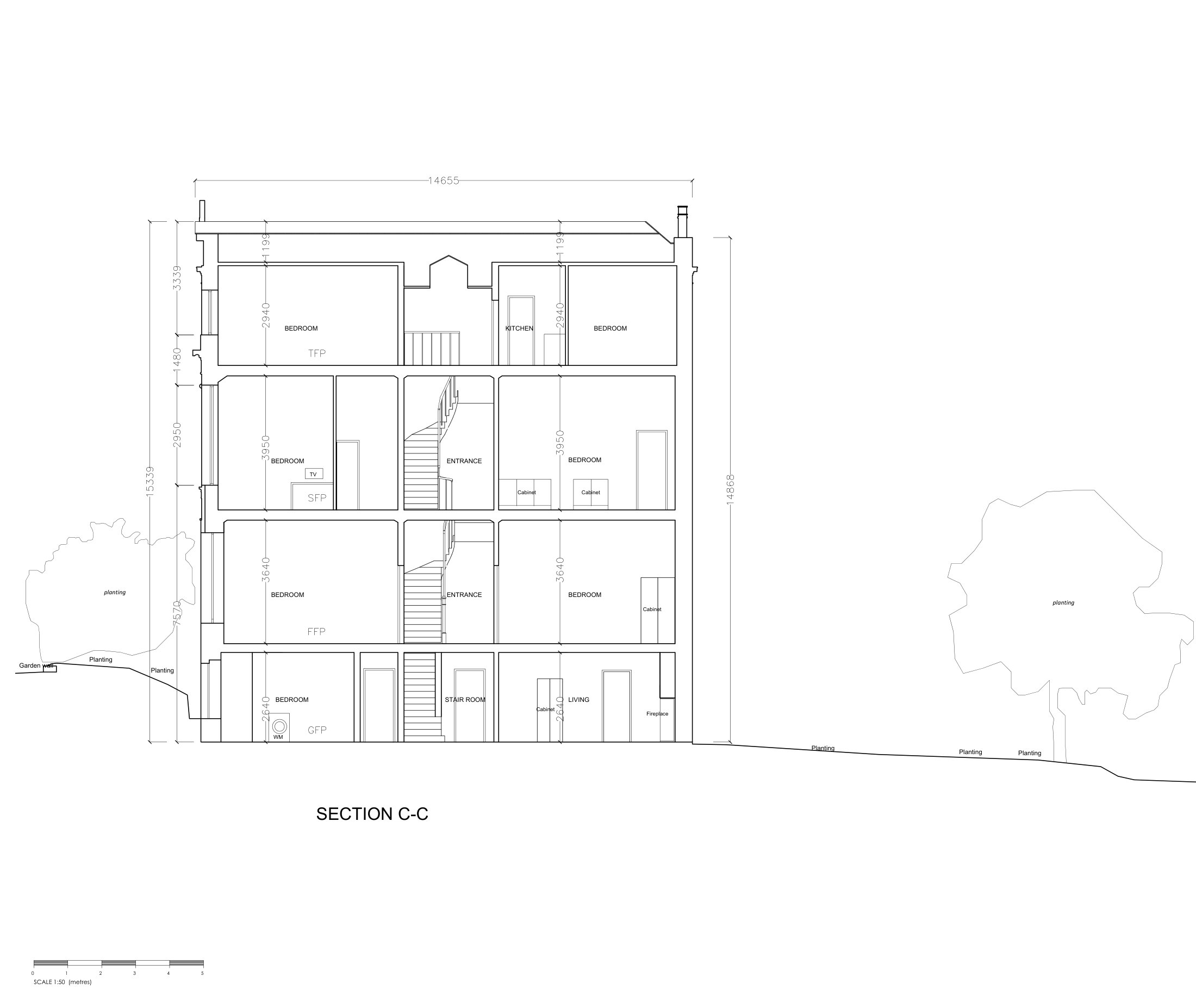
Download the full sample drawing pack (PDF, 10 pages, 1.9 MB) · See the full nine-sheet set and the scan it came from: Victorian townhouse, Glasgow West End →
Where We Survey
Glasgow-based. Scotland weekly. UK-wide by instruction.
We are on site in Glasgow and Edinburgh most weeks, and regularly in Stirling, Dundee, Perth, Aberdeen, Inverness, Fife and the Borders. Larger instructions and multi-building portfolios take us anywhere in the UK.
Measured building surveys in Glasgow
Tenements, villas, listed buildings and commercial conversions across the city and Greater Glasgow — same-week site visits from our base in the city.
Glasgow surveys →Measured building surveys in Edinburgh
New Town and Old Town listed buildings, tenements, villas and commercial premises across Edinburgh and the Lothians — travel built into the fixed price.
Edinburgh surveys →Quick Quote
Get a fixed price — usually the same working day.
Send the address and the drawings you need. No call needed; we come back with a price and a survey date.
Prefer to talk? 0141 260 0115
FAQ
Measured surveys, answered.
What is a measured building survey? +
What drawings do I get? +
What scale and level of detail? +
How accurate are the drawings? +
Can you draw to our CAD standards? +
Do I need 2D drawings or a 3D model? +
Do you cover my area? +
Related Services
Explore more of what we do.
Point Cloud & LiDAR Surveys
3D laser scanning from terrestrial, mobile, and UAV LiDAR
Learn more →Scan-to-BIM
LiDAR point clouds converted to Revit models at LOD 200–400
Learn more →Matterport Surveys
3D virtual tours, floor plans, and point clouds from one visit
Learn more →Drone Surveys
CAA-authorised aerial photogrammetry and thermography
Learn more →Building Performance
Airtightness testing, thermal imaging, and U-values
Learn more →Digital Twins
Navigable 3D replicas of buildings and sites
Learn more →Film, TV & Games
Set, location, and asset scanning for production pipelines
Learn more →Need drawings of an existing building?
Send us the address and what you need — plans, elevations, sections — and we'll come back with a fixed price and scope.